

Our Work Experience
Liberty Geographic service area is widely spread across Washington and Idaho state, mostly in Kootenai and Spokane County. Liberty Geotech also had an opportunity to expand its work to northern Washington and Idaho. The multi-discipline activities and work integrity provide a significant advantage in project development from inception through final construction.

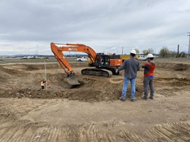
Spokane Airport Water Tower
Liberty Geotech performed geotechnical exploration, excavation observations, and a geotechnical analysis on an elevated water tower near the Spokane International Airport. The water tower will have a net storage capacity of approximately 3.6 million gallons. Unverified to be the world’s largest elevated water tank. The tower foundation will be a concrete ring foundation that has an outer diameter of 85 feet with a ring width of 17 feet. The height of the water tower will be 114-feet tall.
In order to perform exploration, Liberty Geotech used a company-owned CME45 truck-mounted drill rig and company-owned SANY mini-excavator. Over 15 borings were performed ranging from a depth of 5 feet to 25 feet. Shown below are a couple of photographs taken during exploration and excavation observations.

Johnson Creek Bridge
Liberty Geotech performed geotechnical exploration and geotechnical analysis for the Johnson Creek Bridge in the Idaho Panhandle National Forest. The work was done to replace a 24-foot existing bridge located south of Clark Fork, Idaho. The span of the new replacement bridge was 75 feet. Each bridge abutment was supported with a cast-in-place concrete pile cap founded on five driven HP14x102 piles.
The bridge deck was composed of three pre-stressed concrete bulb-tee beams with mounted bridge rail. The total deck width is 16 feet, 6 1⁄2 inches. Each abutment slope is protected with three feet of Class 4 rip-rap on a 1.5H:1.0V (horizontal to vertical) slope.
Two exploratory borings were performed to a depth of 50 feet below the ground surface. Soil sampling was performed at 2.5-foot intervals and then at 5-foot intervals once a depth of 10 feet had been reached. Shown below are a couple of photographs taken during exploration.
